Italian mapmakers began incorporating cartouches on their maps as early as the 1500s. Initially they designed simple scrolls, and when the Dutch and Flemish became the leading cartographers in the mid 1500s, more embellishments were added: animals, mythical creatures, masses of flowers and fruit, kings, queens, gods and goddesses, cherubs, and architectural detail. (Source: maptheuniverse.com).
The decorative qualities of the cartouche had influences of both Baroque and Rococo.
BAROQUE is a style of decoration developed in late 16th-century Italy characterized by exaggerated form and extravagant ornamentation. Cartouches on maps from this period were often in a Baroque style, and featured cherubs, leaves, fruit, animals, and allegorical figures. Baroque art is large in scale and filled with dramatic details.
1. See cherubs on this cartouche on a Dutch map of 1657 (image courtesy of www.helmink.com).
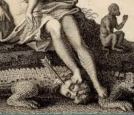
 it, a crocodile, two monkeys, and a female figure with a child, pointing to scenes of trade and commerce. (Image courtesy of www.davidrumsey.com).
.jpg)
ROCOCO, which originated in France in mid-18th century, succeeded Baroque with a simpler style of refined scrollwork, scalloped shells and foliage.

3. This cartouche is from an English country map by John Owen and Emanuel Bowen, circa 1730. (Image courtesy of www.earlymaps.com).

4. This cartouche from Emanuel Bowen’s A Map of Marco Polo's Voyages & Travels in the 13th Century, London, 1744, shows Marco Polo trading with Asians. (Image courtesy of www.murrayhudson.com).
By the mid-19th century, many map cartouches showed actual views of cities or landscapes. In the 20th century the decorating of maps with a maker’s cartouche had become less important.
DID YOU KNOW that all antique maps were printed in black and white since color registration (the alignment of different print plates) had not been perfected yet; therefore maps had to be hand colored.
